The West Highland Way is a 96mile long walking route in Scotland from Fort William to Milnagavie.
It is currently celebrating it's 40th year since inception.
I decided to ride it on mountain bike at the end of last year.
I’ve been aware of the West Highland Way long distance walk for as long as I can remember, but I have never done the full distance. I’ve done small parts, just as part of different routes, both on walks and cycles. It such a long, well known walk though, that tourists and locals all seem to do it at some point. Coming across the route during various other travels I’d always been surprised at quite how busy with walkers it seemed to be. I always wanted to do it.
Eventually, after seemingly winding our way back and forth across the country, the train I was travelling on passed close in to some mountains that looked ominously large as the sun got low, casting shadows across the world. A few minutes later we pulled into Fort William station.
I spent the night in a cheap hotel before setting off at 6am the next morning.
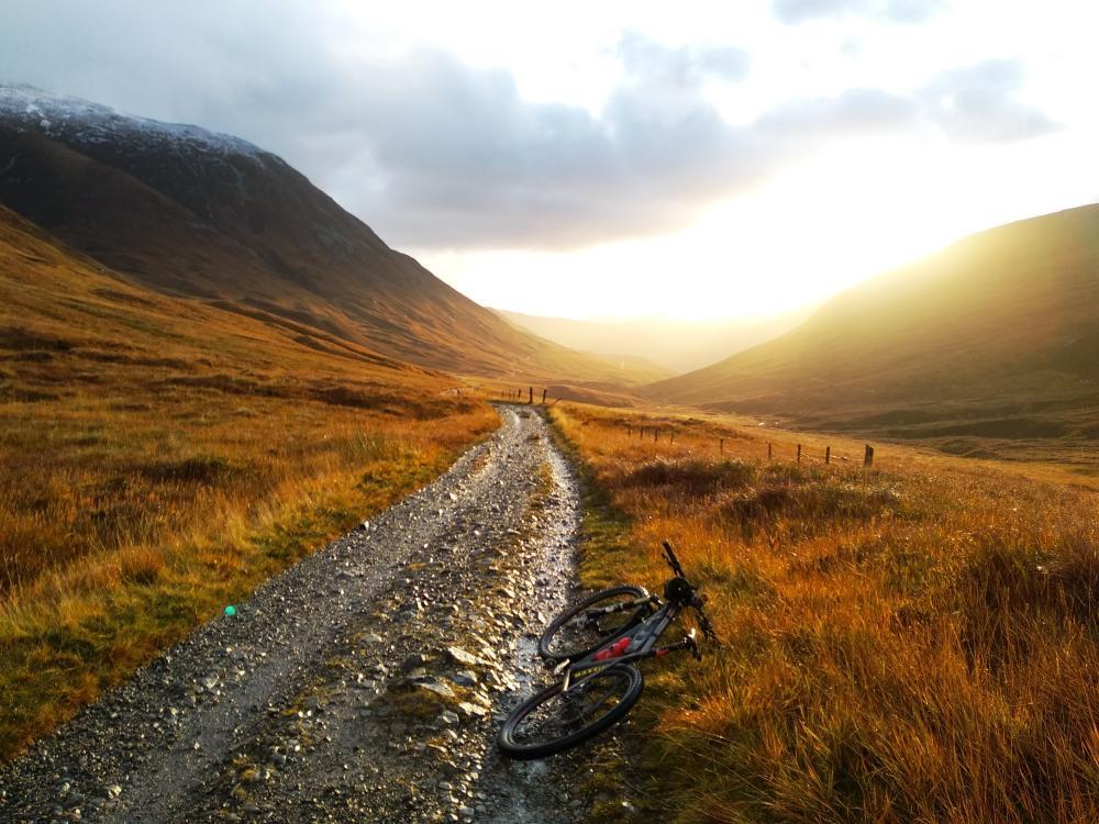
It was cold outside. I turned my bike lights on, took a photo, switched on my GPS with the West Highland Way route loaded on (a necessity after doing it, the signs aren’t great and aren’t meant to be noticeable by faster moving cyclists!)
Down the high street I cycled. A confused moment trying to figure out which path exactly I was supposed to be following (already the GPS was coming in handy). A short cycle through the town and then…darkness. I headed up the road which leads up Glen Nevis. My tiredness disappeared. As did any questions about why I was doing this. I was cycling out of Fort William, in the dark, feeling good, on a mini adventure I’d been wanting to do for a while. It started to rain.
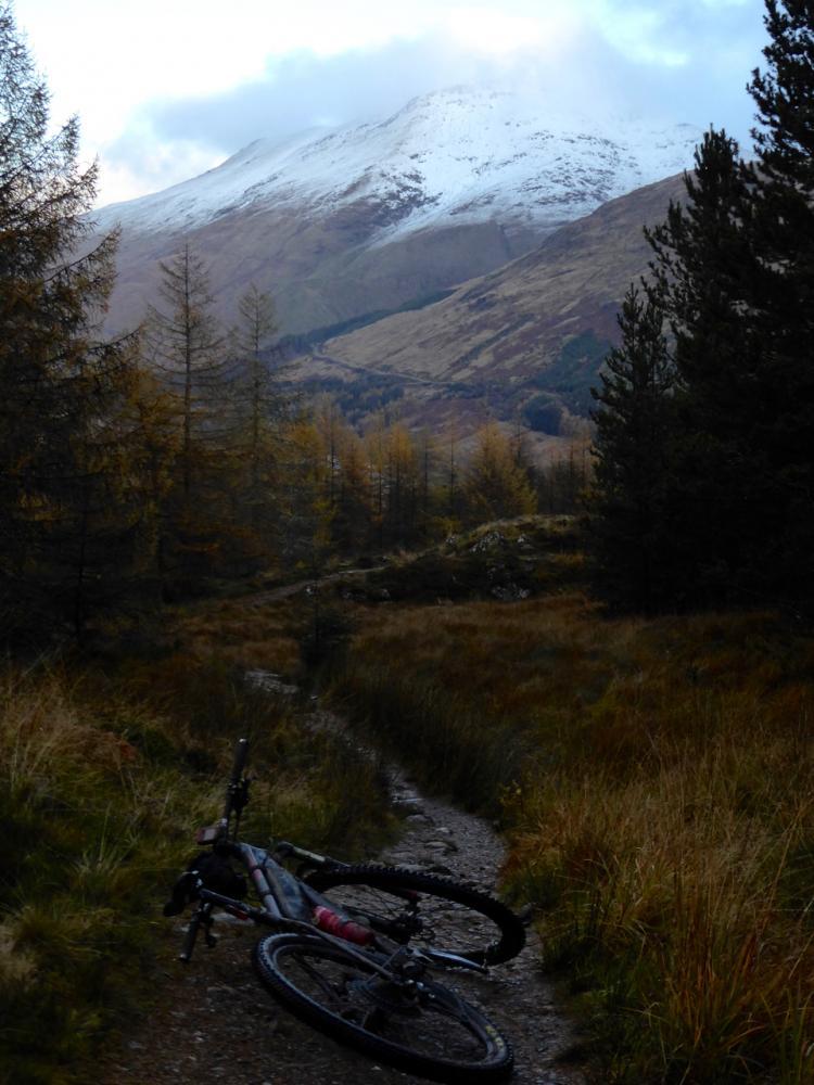
A short distance more and I turned off of the road and onto a muddy path which quickly headed upwards. Through the trees I rode, following the path as it zig-zagged its way higher up the steep hillside before joining a track road which continued on around the contours of the hill. On the opposite side of the valley was the highest mountain in Britain, Ben Nevis. I stopped and watched as in the distance tiny strings of lights shone along the mountain path as a few groups of early risers bobbled about, making an early start on their climb.
Soon I found myself riding along a long and desolate valley. A massive cut right through the Mamores mountain range. I followed it south along a track road which had a rough surface, making going slower than you’d guess from just looking at a map. I was enjoying it though.
The sun very suddenly appeared around the side of the mountain to my right, turning everything ahead of me a beautiful golden colour. I stopped to take some photos and enjoy the primeval and possibly imaginary warmth that came with the brighter world.
A little way up the road I emerged from the depths of the valley and out into the open hillside looking south. I was now getting close to the next major point on the route; Kinlochleven.
Suddenly I found myself on a very steep rocky descent. It was fun for a few minutes, but ahead the rocks loomed large and I could see several drainage diches running across the path. I was on my own, and had a long way to go. I played it safe and decided I should walk down this bit. Deciding this was one thing, actually managing to stop and dismount was another. I skidded downwards, right on the edge of control. Trying to slow as much as I could without losing control. I tensed up as I realised it wasn’t going to go my way. Sometimes, when this happens, you have to decide whether to bail out and try to survive the inevitable crash, or just go for it and ride it out. I went for it. Bouncing and scraping between the rocks, I just managed to lift the front wheel over each of the drainage ditches, the rear wheel following, rolling over with a clank. I rolled around the bank on a shallow corner and then on a slightly less steep section where finally I was able to come to some kind of a controlled stop.
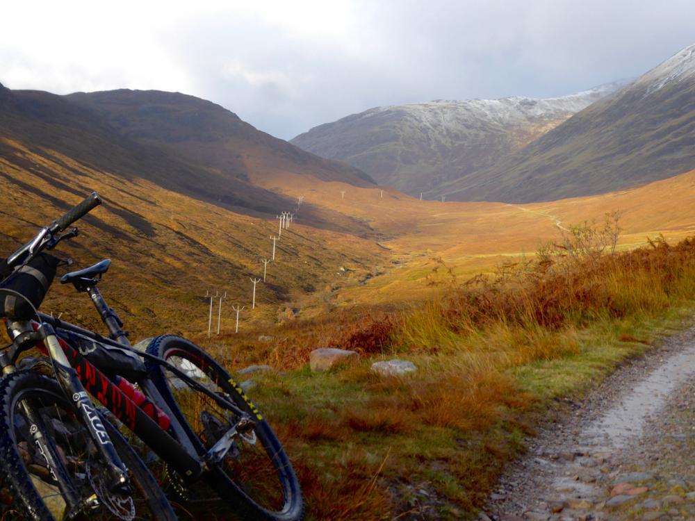
Kinlochleven used to be two small hamlets, Kinlochmore to the north and Kinlochbeg to the south. Between 1905 and 1907 a dam was built above the hamlets to provide a power source for an aluminium smelter. The work involved in building the dam brought people to the area, new housing was built and the town was formed.
I circled around the middle of town taking a look at a waterfall. There wasn’t much happening in a small town on a saturday morning, certainly no cafes open, so after finding the path for the continuation of the West Highland Way I decided to keep going. I’d had it in my mind that I’d probably be able to make it to the Glencoe Ski centre for an early lunch. That was still about rese away. So although I was going slower than I’d hoped, it still seemed fairly do-able. Although I knew there were some hills in-between.
I was soon climbing a steep track road alongside the steel pipes transporting water down the hill from the dam. The pressure of the water in the pipes was evident from the many fountains of water creating rainbows as they streamed into the air from leaks in the pipes. Bloody hell this track was steep. I was in my largest cog, grinding the pedals around.
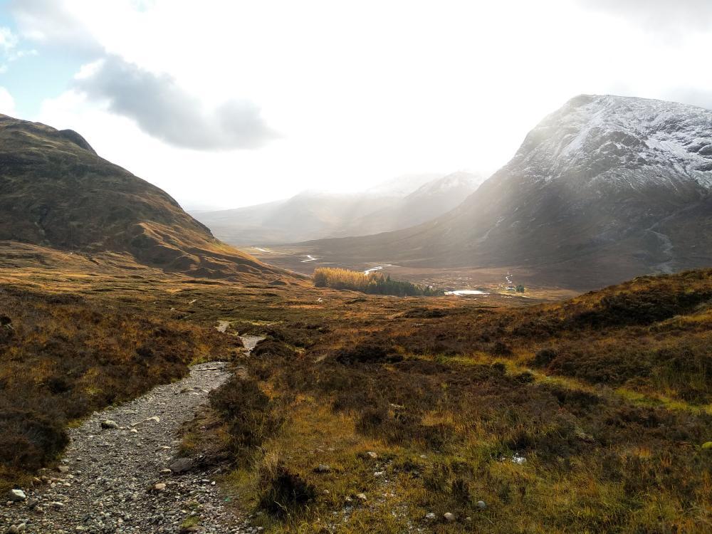
The path wound its way higher and into the snow line. Patches of snow crunched as I cycled over. It was getting noticeably colder up here. After a particularly steep section I found myself in the saddle between two mountains, the craggy Beinn Bheag at 616 meters, and the more imposing Stob Mhic Mhartuin at 707 meters. The view opening out in front of me as I reached a snow covered cairn was absolutely stunning.
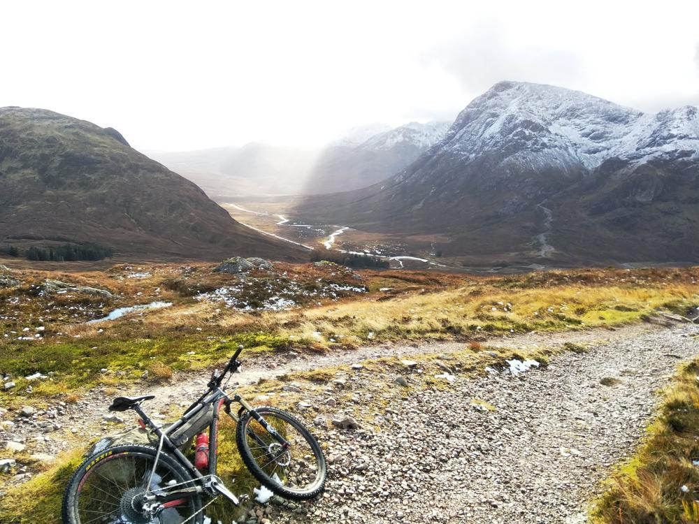
I was at the top of the aptly named Devil's Staircase, one of the highlights of the West Highland Way route. In front of me was the deep valley of Glencoe stretching out towards Rannoch moor in the south. Directly in front me, on the opposite side of the valley, was the mountain of Buachaille Etive Mor.
It was my turn to traverse the staircase. I had been looking forward to this. Rolling over the top of the hill I could see the path winding it's way down the hill in front on me. I very quickly forgot about the views and was fully concentrated on the steep and rocky path in front of my wheel. This was at the limits of my technical ability while carrying extra weight on the bike. But I was determined to ride it as much as I could. Feathering the brake levers, so as not to lock a wheel, I sometime fast, often slowly worked my way down the mountain. The path was not free from drainage culverts some could be attacked with speed carrying me safely across the gaps. Others needed more care. Almost coming to a complete stop I had to hop the wheels over, or head momentarily into the undergrowth or gaps down the edges which were rideable. I was also acutely aware that this was a walking path.
Passing the Kinghouse hotel it looked busy so I decided to try the cafe up at the ski centre on the opposite side of the valley.
As I ate, I watched the nearby gondola whirring around as a few people climbed on for a trip up the mountain. I sat for longer than I'd planned. This was not a time to rush, I needed to recover if I was to continue at all. In terms of distance I was only just over a third of the distance I'd planned for today. It was two pm, much later than I'd planned to be here. Oh well.
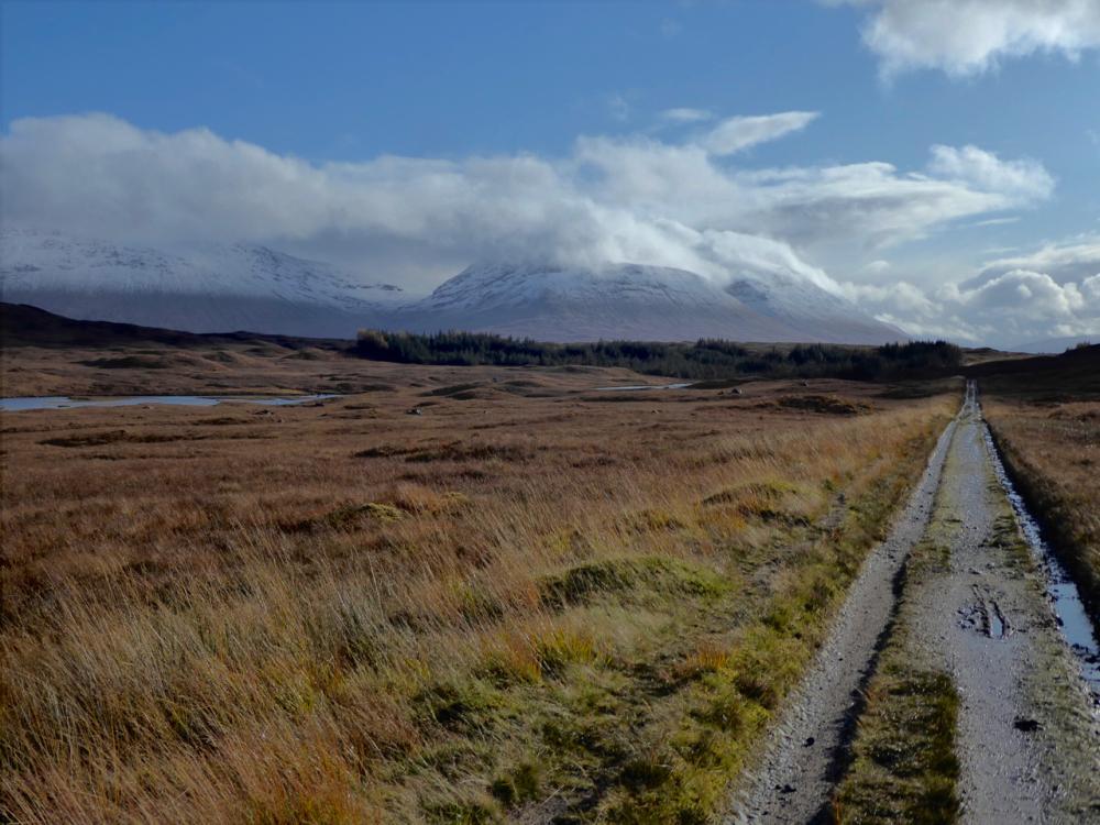
I hit the pebble cobbled track road heading across Rannoch moor. “Jesus, this is rough!” as my bike bounced around underneath me. There was no-one around. The moor stretched out around me. Suddenly rearing up in magnificent mountains at the edges.
The rain started in earnest, the wind picking up at the same time. Soon the rain turned horizontal, then the horizontal rain turned to horizontal hail. I covered my face with my jacket as best as I could but the hail still stung my skin. A bright rainbow was now stretching across the moor.
I found myself covering the kilometres quickly. I was loving the isolation, the drama of the watery landscape. The track was slowly descending, helping my progress. Some beautiful bridges, a lovely descent along the edge of a forest, and I found myself at Victoria Bridge at the end of the pretty loch Tulla. I thought I'd be descending all the way to Bridge of Orchy. However, now that I looked at the map more closely, I saw that there was quite a big hill between me and the small village. “Oh well”. I struggled upwards, once again at a considerable gradient. This hill wasn't too high though and I was soon over the top and heading down the twisty fast path to the town on the other side.
The continuing path was steep and rocky as it climbed and traversed the lower slopes of Beinn Dorain (hill of the otter in Galic) From the south, this mountain is very noticable and stands out amongst its neigbours thanks to it's almost symetrical conical shape.
As I covered the kilometers it gradualy became easier to cycle and soon enough after crossing an old bridge back over the railway line the track surface became good. It was too good to last though as dropped down to the river at the valley floor I came to a deep and fast flowing tributary. The bridge was missing. Possibly washed away in the storms of the previous week, there was now a gaping hole between the two concrete legs standing either side of the water. There was a small sign attached to a nearby fence. On it a map of a diversion. It suggested I climb the side of the river and cross at a small bridge upstream. It looked to be a couple of kilometers of diversion, up a hill, over a rough or non-existant path. “Bollocks to that” I possibly said out loud. Climbing down the embankment just down stream of where the bridge had stood wasn't too bad. I didn't bother to take my shoes or sock off, it would have been fairly pointless at this stage of the day. My feet were already pretty soaked and cold. I waded across a shallow section which actually wasn't too bad. The other side proved more difficult. I climbed back out of the river and lifted my bike above my head and onto the safe ground above before scrambling up after it.
Soon I hit the downhill track road leading into the busy village of Tyndrum
A few kilometres further, I passed the town of Crianlarich. I didn't see it though. It was hidden by the trees, somewhere down below as I rode along a lovely set of paths through a forest on a nearby hillside.
As I raced down a hill, I again met up with the main road. I pedaled through an underpass. Looking at my GPS I could see I was on the home stretch. My planned stopping point for the night was close.
oon enough though I reached the Beinglas campsite. Handily the West Highland Way goes right though the campsite. Swinging into the car park I noticed there was a handy wooden shelter which I rode my bike straight into. Apart from a few pieces of luggage it was empty. I took a moment to sort my stuff out. I was very happy to discover that this campsite had it's own pub. I was even happier to discover that I had two hours left until they stopped serving food.
Click here for part 2